Land, Agriculture, and Wildlife Habitat
The Mississippi River Basin (MsRB) occupies more than 750,000 square kilometers (293,000 square miles), covering part or all of 14 states from Minnesota to Louisiana, with the total river length of approximately 3700 to 4000 km (2300 to 2500 miles). The drainage area of the Mississippi River upstream of the confluence with the Ohio River (not including the Missouri River Basin (MRB)) is known as the Upper Mississippi River Basin and that downstream of the Ohio River confluence (not including the Arkansas – White – Red River Basin) is known as the Lower Mississippi River Basin. The Basin is home to at least 11 Native American tribes. There are sparsely inhabited agrarian counties as well as large metropolitan areas such as Minneapolis – St. Paul, St. Louis, Memphis, New Orleans, and Baton Rouge in the Basin. Inhabitants of the Basin depend on the Mississippi River and its tributaries for drinking water, irrigation and industrial needs, hydro-electricity, recreation, navigation, and fish and wildlife habitat. The MsRB produces approximately 74% of the corn, 79% of the soybeans, and 24% of the wheat produced in the U.S..
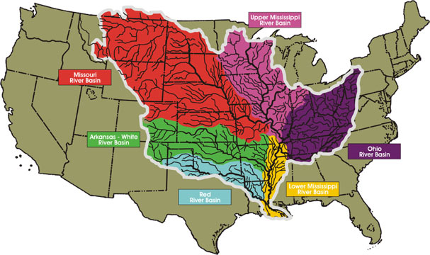
Figure 1: Upper (light purple) and Lower (yellow) Mississippi River Basins.
The Mississippi River and its floodplain are home to a diverse population of wildlife, including at least 260 species of fish (25% of all fish species in North America). Forty percent of migratory waterfowl use the river corridor during their spring and autumn migration, and 326 species of birds (60% of all North American birds) use the river corridor as their migratory flyway. The Upper Mississippi River is host to more than 50 mammal species, and at least 145 species of amphibians and reptiles inhabit the Upper Mississippi River environment.
Transportation of Food, Feed, Fuel, and Other Materials
Approximately 650 million tons of cargo, valued at over $75 billion, is transported on U.S. inland waterways every year. Barge transportation benefits the national economy by providing a more fuel-efficient alternative to rail and road transportation for many commodities including grain, coal, petroleum, and chemicals. On one gallon of fuel, 1 ton of cargo can be moved 60 miles by truck, 202 miles by rail, and 514 miles by barge. Also, one barge holds as much as 15 jumbo rail hoppers or 58 semi truck trailers. Therefore, barge transportation is the most cost-efficient and convenient mode of transportation of bulk materials.
Grain corn accounts for approximately 10-12% of all U.S. agricultural exports. The U.S. contributes 50-60% of global corn exports. The U.S.’s shares of the world’s wheat and soybean exports are approximately 20% and 40%, respectively. Sixty percent of all grain exported from the U.S. is shipped on the Mississippi River from its main production regions in the MRB and the MsRB to the Port of New Orleans and the Port of South Louisiana on the Gulf of Mexico. Representing 500 million tons of shipped goods per year, the Mississippi River barge port system is significant to national trade. To move goods up and down the Mississippi, the USACE maintains a 9-foot deep shipping channel from Baton Rouge, Louisiana, to Minneapolis, Minnesota. From Baton Rouge to New Orleans to Head of Passes, a 45-foot deep channel is maintained to allow ocean-going vessels access to ports between New Orleans and Baton Rouge.
The Middle Mississippi River is the segment of the Mississippi River from the confluence with the Missouri River at St. Louis, Missouri, to the confluence with the Ohio River at Cairo, Illinois – a distance of approximately 320 km (200 miles). Approximately 120 million tons of cargo is shipped on the Middle Mississippi River each year. Agricultural products are the main cargo shipped, with corn, soybean, and wheat making up a large percentage of the total. Other major cargoes shipped include coal, raw materials (including sand, gravel, iron ore, and scrap iron), manufactured products, petroleum products, and chemicals. Much of the agricultural cargo is destined for export through ports on the Gulf of Mexico. There are no locks or dams downstream of St. Louis to maintain water levels, so inland navigation on this stretch of the River is vulnerable to natural flow variations and, therefore, navigation on this stretch of the Mississippi River is perhaps the most vulnerable to natural flow variations due to climate variability and changes. Dikes, bank revetments, and dredging are used to maintain a navigable channel in the Middle Mississippi River.